
2016 – Watch the full lecture
 Prof James Best, Department of Geology, Geography & GIS, University of Illinois
Sedimentology of the fluvial-tidal transition: insights from the lower Columbia River, USA, and some simple laboratory experiments
In the Western Scheldt the large-scale pattern of inter-tidal flats has changed. In the beginning of the twentieth century the flats consisted of complexes with several smaller flats with complex and long waterlines, intersected by channels. Today’s pattern shows large flats with smooth circumferences and very few intersecting channels. The transition towards larger and smoother flats is ongoing. The origins of this development under debate, with likely relations to the autonomous development of the channel pattern and to the embankments. The implications of these morphological changes for the hydrodynamics of the estuary are not yet fully understood.
The distribution of mega-ripple beds over the inter-tidal flats (for the distribution in the sub-tidal realm the number of observations is limited) has changed over the recorded period of ’70 years and the spatial extent of the mega-ripple beds has decreased. Fields with mega-ripples typically occur along the fringes of the inter-tidal flats, where ebb and flood chutes protrude in to the flats. Along with the decrease of the mega-ripple fields the areas with flats beds have increased. These flat flats are interpreted as upper-stage plane bed areas. The transition from mega ripples to upper-stage plane bed is a function of several factors (current velocity, depth, grain size, etc.) and the key factor has not yet been identified.
Things have changed in the hydrodynamics and the sediment dynamics of the tidal flats. The two developments presented here appear on very different spatial scales, but are likely related. The presence of mega-ripples is associated with the small-tidal channels that used to dissect the inter-tidal flats and both are decreasing. Getting grip on these developments- and many others- requires fundamental knowledge, both on the large spatial scale of pattern formation and development in the estuary and on the much smaller scale of bedform generation and dynamic. In order to retain the values of the Scheldt estuary for society insight in its dynamics is imperative.
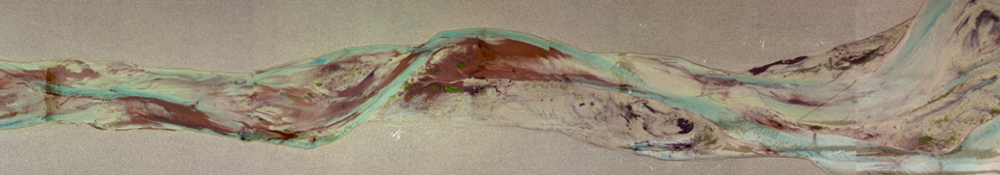
 Dr. Jelmer Cleveringa, Arcadis Nederland
Ripples in the Scheldt
In the Western Scheldt the large-scale pattern of inter-tidal flats has changed. In the beginning of the twentieth century the flats consisted of complexes with several smaller flats with complex and long waterlines, intersected by channels. Today’s pattern shows large flats with smooth circumferences and very few intersecting channels. The transition towards larger and smoother flats is ongoing. The origins of this development under debate, with likely relations to the autonomous development of the channel pattern and to the embankments. The implications of these morphological changes for the hydrodynamics of the estuary are not yet fully understood.
The distribution of mega-ripple beds over the inter-tidal flats (for the distribution in the sub-tidal realm the number of observations is limited) has changed over the recorded period of ’70 years and the spatial extent of the mega-ripple beds has decreased. Fields with mega-ripples typically occur along the fringes of the inter-tidal flats, where ebb and flood chutes protrude in to the flats. Along with the decrease of the mega-ripple fields the areas with flats beds have increased. These flat flats are interpreted as upper-stage plane bed areas. The transition from mega ripples to upper-stage plane bed is a function of several factors (current velocity, depth, grain size, etc.) and the key factor has not yet been identified.
Things have changed in the hydrodynamics and the sediment dynamics of the tidal flats. The two developments presented here appear on very different spatial scales, but are likely related. The presence of mega-ripples is associated with the small-tidal channels that used to dissect the inter-tidal flats and both are decreasing. Getting grip on these developments- and many others- requires fundamental knowledge, both on the large spatial scale of pattern formation and development in the estuary and on the much smaller scale of bedform generation and dynamic. In order to retain the values of the Scheldt estuary for society insight in its dynamics is imperative.